Kaštela
via Dubrovnik & Kaštela (14 Days).
Croatia Yachting's 14-day Kaštela round trip — south through Šolta, Vis, Lastovo and Mljet to Dubrovnik, back via Korčula, Hvar and Brač. Broker briefing notes day by day.
Day-by-day route
Click any pin on the map or any day in the Route summary below to see the daily stop, narrative, and photos.
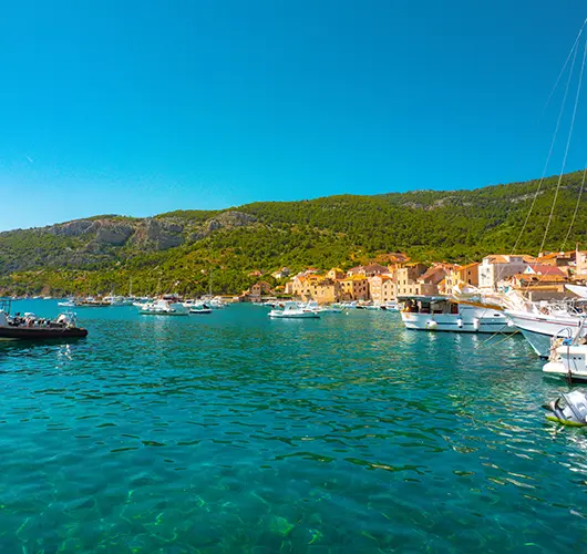
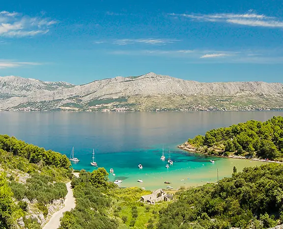
Kaštela → Maslinica (Šolta)
Thirteen miles south-southwest off the Kaštela pontoon into Maslinica — Šolta's only natural deep-water harbour, walled by a chain of seven small islets across the entrance, and the calm first-night anchorage our briefings recommend every Saturday.
Distance
10 NM
Sailing
~2h at 5 kn
Route at a glance
Best season
May – early October (peak Jun – Sep)
Duration
14 days · Sat – Sat
Departure
Kaštela
Sailing area
Split
Route summary
Click any day to jump back to the map and see its photos, narrative, and mooring tip.
Day-by-day journey
Named anchorages, restaurants, and route notes for every leg of the week — written by sailors who've actually run this passage.
Kaštela → Maslinica (Šolta)
Saturday turn-around at Marina Kaštela clears the outgoing column by about 16:30, so our base team sets the on-board briefing for 15:30 and slips charters out behind the rush. Thirteen miles south-southwest takes you across the Split Channel to Maslinica on the western tip of Šolta. The seven-islet chain across the entrance kills any open-Adriatic swell and makes the approach unmistakable from two miles offshore. Two berthings share the bay: Martinis Marchi Marina on the south side runs lazy lines and a working 18th-century baroque-castle hotel; the village quay on the north side takes stern-to with own anchor at a modest harbour fee. Šolta runs quieter than Brač or Hvar by an order of magnitude — no day-tripper ferries, three konobas around the village square, one bakery, one small grocer. The standing pairing is the indigenous Dobričić red against Šoltansko olive oil; both stocked at the corner shop next to the parish church.
Things to do
Walk the Martinis Marchi castle courtyard and the chapel ruins on the rise above it
Pour the Dobričić — Šolta's indigenous red — at Konoba Šišmiš in the village square
Snorkel the channel between Polebrnjak and Stipanska islets at the bay mouth
Sit on the headland west of the village for the open-Adriatic sunset
Pick up two litres of Šoltansko olive oil before the morning departure
Mooring tip
Martinis Marchi Marina on the south side has lazy lines, water and power, plus a full-service block — summer rate around €100/night for a 50 ft mono, online booking essential in July–August. Village quay on the north side accepts stern-to with own anchor at a modest harbour fee (water tap on the central section, no power). The seven-islet chain at the entrance blocks all S, SW, W and NW swell; only N gradient pushes chop in, and that's rare in summer. Anchorage holding in the centre is sand-and-weed in 5–8 m, mostly good with a second pass to set.
Maslinica → Milna (Brač)
Twelve miles east across the Brač Channel takes you into Milna, the long deep inlet on the western side of Brač that has been a working harbour since the Venetian era. The approach reads itself: the 17th-century parish church marks the inner quay, the bay narrows past it, and the inner town line accepts stern-to with own anchor for the entire eastern half of the harbour. Outer half is the working anchorage in 6–10 m of sand; the standard configuration here is anchor plus stern line to the rocks if the afternoon Maestral builds above 15 knots. Brač runs on two reputations — the white limestone quarried at Pučišća on the north coast (the same stone the Romans cut for Diocletian's Palace), and peka lamb cooked under embers, which is the Sunday lunch tradition the village keeps the whole year round. The peka order is non-negotiable on timing: call by 14:00 to sit down at 18:00. Our base ops desk radios the call the morning of departure if the crew commits to it at the briefing.
Things to do
Phone the peka order in by 14:00 for an 18:00 sit-down ashore
Walk the trail above the village to the old limestone-tile quarry workings
Set anchor plus stern line to rocks in the outer bay if the Maestral builds
Pick up a bottle of Plančić Plavac on the walk back from dinner
Dinghy three miles north to glassy Bobovišća for a quiet sunset swim
Mooring tip
Inner town quay stern-to with own anchor — water and power on the central section, harbour fee around €25 for a 12-metre charter, settled at the kiosk. Outer half of the bay accepts free anchoring with stern line to the rocks (standard configuration). Bay is open to W and SW; if the Maestral pushes above 15 knots in the afternoon, the inner quay stays comfortable through the night. Holding in the outer bay is sand-and-weed in 6–10 m, mostly good with a second pass to set.
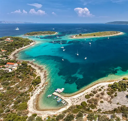
Milna → Palmižana (Hvar)
Fifteen miles southeast from Milna across the Hvar Channel and the Pakleni chain opens off the bow: the long string of pine-covered islets that protect Hvar Town from the south. The chain runs roughly a mile offshore — outermost is Sv. Klement, the largest, then Marinkovac, then a string of smaller islets down to Jerolim and Galešnik. Palmižana sits on the east side of Sv. Klement and is the only one of the cluster with a marina (ACI Palmižana — stern-to lazy lines, summer slots tight, online booking ten days ahead is the realistic call). The main bay holds in 5–10 metres of sand and weed but turns rolly when the Maestral funnel kicks in around 14:00, so our preferred overnight when the marina is full are the south-side coves Vinogradišće and Tarsce — both take line ashore as standard set-up. The afternoon ritual on Palmižana runs in three parts: the Meneghello 1906 botanical garden, the four konobas around the bay rim, and the snorkel over the submerged Roman amphorae off the western shore.
Things to do
Snorkel the Roman amphora field on the western shore of the islet
Walk Meneghello's 1906 botanical garden between the four konobas
Cross to Vinogradišće with line ashore if ACI Palmižana runs full
Hire the water taxi over to Hvar Town for an evening stand
Take the footpath across Sv. Klement to Vlaka Bay for lunch
Mooring tip
ACI Marina Palmižana stern-to with lazy lines — online booking essential for July–August, summer rate around €130–€160/night for a 50 ft mono. If the marina is full, anchor with line ashore in Vinogradišće on the south side (sand and weed in 6–10 m, line ashore standard) — better protection from afternoon Maestral than the main bay. The main Palmižana cove is exposed to SW gradient overnight and uncomfortable above 15 knots from that direction.
Palmižana → Komiža (Vis)
Twenty-three miles southwest from the Pakleni cluster lands you on Vis — the most westerly inhabited Croatian island and a place that still reads two decades back from anywhere else in central Dalmatia. Vis was a closed Yugoslav military zone until 1989 — no foreign visitors allowed — and the absence of resort-era development from that period is visible everywhere on the island. Komiža wraps around a small bay on the western coast: the inner basin takes stern-to with own anchor on a sand-and-weed bottom (mostly good holding), and the outer harbour wall is open to SW swell and unsuitable overnight. The town is small enough to walk in fifteen minutes — the working fishing fleet ties up on the eastern side of the harbour, the Fishermen's Museum in the old Venetian tower opens afternoons, and the konoba shortlist runs to grilled bogueroni paired with the indigenous Vugava white. Vis was also the WWII coordination centre between Tito's Partisans and the British SOE; the cave on Mount Hum is open as a site, and the hike up earns you the best 360° view in the central Adriatic.
Things to do
Walk the working fishing fleet along the eastern wall before sunset
Order grilled bogueroni and a glass of indigenous Vugava at a town konoba
Hike Mount Hum (587 m) to Tito's WWII cave for the central-Adriatic panorama
Stand at the Fishermen's Museum in the Venetian tower one afternoon
Dinghy across to Mali Barjak islet for the clearest snorkel on Vis
Mooring tip
Stern-to with own anchor on the inner basin of Komiža town quay — sand and weed in 4–7 m, holding mostly good with a second pass, harbour fee around €30/night for a 50 ft mono. Outer harbour wall is exposed to SW swell and not safe overnight. If SW gradient is forecast above 15 knots, push 6 nm north to Vis Town in St. George Bay — fully sheltered, with both marina and town quay available.
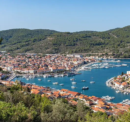
Komiža → Blue Cave (Biševo) → Green Cave (Ravnik) → Vela Luka (Korčula)
The day's calendar is dictated by the sun angle inside the Blue Cave on Biševo: the underwater opening lights the cavern an unreal ultramarine only between roughly 09:00 and 11:00, after which the colour fades to grey. Tie alongside the small concession quay outside the entrance (no overnight, lunchtime fee paid at the kiosk) and queue for one of the official tenders that ferry visitors in — private dinghies aren't allowed inside. Forty minutes in and out, then back on board for the short hop east to Ravnik islet and its Green Cave (Zelena Špilja). Green lights through a roof opening rather than underwater, is open to private dinghies, and runs much less crowded than Biševo — the cavern floor reads emerald when the sun is overhead. By early afternoon the heading bends 18 miles southeast to Korčula's Vela Luka — a deep west-facing harbour with full town services, a fuel pump on the western end and one of the most sheltered overnight bays on the south coast. The evening pick is žrnovski makaruni, the local hand-rolled pasta, at one of the konobas back from the quay.
Things to do
Queue at Biševo for the Blue Cave tender between 09:00 and 10:30
Dinghy into the Green Cave at Ravnik — private entry allowed here
Track the south face of Vis on the leg east toward Korčula
Order žrnovski makaruni hand-rolled at a Vela Luka konoba
Walk the long waterfront promenade at dusk before dinner
Mooring tip
Vela Luka stern-to with own anchor on the long town quay — modest fee around €25–€35 depending on length, water and power on the central section, fuel pump at the western end. Holding is excellent — mud and sand in 4–8 m. Bay is fully sheltered from N, NE and E; only S gradient above 18 knots pushes any swell into the inner harbour, and even then the inner pontoon stays comfortable through the night.
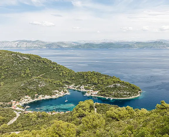
Vela Luka → Lastovo (Zaklopatica)
From Vela Luka the heading bends south for fourteen miles across to Lastovo — a Nature Park, the lowest light-pollution rating in Croatia, and the quietest inhabited Adriatic island in the season. Zaklopatica is the natural overnight call: a U-shaped bay carved into the north coast with a low islet across the mouth breaking any swell, and five family-run konobas that each lay a string of free mooring buoys for guests who eat ashore. The mooring economics are simple — book a buoy and a dinner table at the same konoba, and the buoy comes free. Anchoring on bottom is discouraged because of the seagrass meadow (Posidonia conservation rules), but the buoy field has plenty of capacity outside July peak. Lastovo specialities are the local lobster (jastog, caught daily on traps north of the island) and šporki makaruli, a rustic beef-pasta stew that the konobas have kept as the year-round signature. Off the water there is deliberately little to do — which is the entire point. The island has the lowest light-pollution rating in Croatia; on a clear August evening the Milky Way comes directly overhead before midnight.
Things to do
Hail a konoba on VHF Ch10 at 11:00 the morning of arrival to book the buoy
Order Lastovo lobster (jastog) fresh-trapped — priced by weight at the table
Walk inland to Lastovo Town and the cluster of rebuilt fumari chimneys
Snorkel the small islet across the bay entrance
Stay up on deck after midnight — clearest sky anywhere in the Adriatic
Mooring tip
Free konoba mooring buoys at Zaklopatica — confirm on VHF Ch10 at 11:00 the morning of arrival, dinner reservation locks the buoy. Anchoring on bottom is discouraged due to the seagrass meadow (Posidonia conservation rules). Bay is fully sheltered from N round to W; if SE forecast goes above 15 knots, move 4 nm south through the channel to Skrivena Luka (also called Portorus) — the island's all-weather alternative.
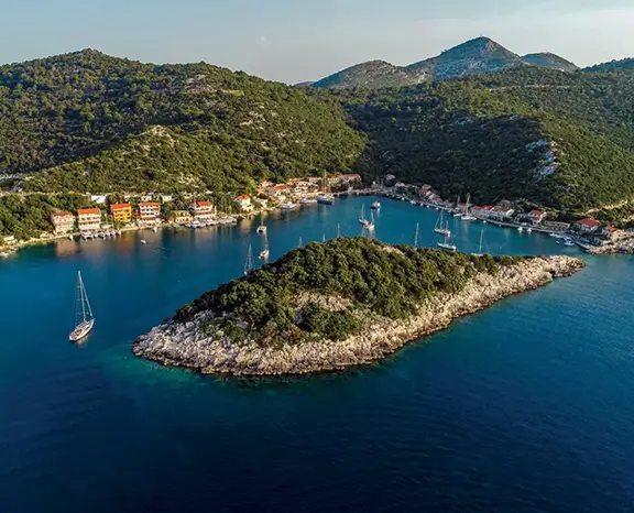
Lastovo → Mljet (Polače)
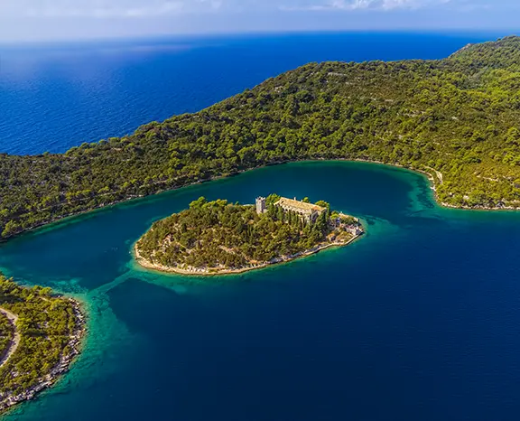
Mljet is a 22-mile run northeast from Lastovo, and the second half of the leg delivers the most dramatic landfall on the entire route — Polače, a long walled inlet on Mljet's north coast, the entrance unobtrusive until you slip inside it, then opening out into one of the best-sheltered overnight bays in southern Croatia. Polače is the western landing of the Mljet National Park. The remains of a 4th-century Roman complex sit metres back from the waterfront — basilica walls and the corner tower are the obvious survivors and can be walked through without a fee. The bay itself is managed by the Park: pick up one of the green Park buoys (overnight fee paid at the ranger kiosk on the waterfront, includes Park entry for the crew), or take a stern-to slot on the small village pontoon. From Polače a 30-minute walk leads to Veliko Jezero, the larger of Mljet's two saltwater lakes, where a small Park ferry runs out to the 12th-century Benedictine monastery on St. Mary's islet. The trail loops both lakes in about 9 km, swimming is allowed, cicadas the only soundtrack.
Things to do
Pay the ranger for a Park buoy on arrival at the waterfront kiosk
Step through the 4th-century Roman basilica ruins on the quay
Take the Park ferry out to St. Mary's monastery on Veliko Jezero
Hike the 9 km loop trail through both saltwater lakes inside the Park
Swim in the saltwater lakes — five degrees cooler than the open sea
Mooring tip
Polače uses paid Park mooring buoys (2026 rate around €45/night for a 50-foot boat, including crew Park entry) — pay the ranger on arrival. Bay is one of the best-sheltered overnight options on the entire south Croatian coast: fully protected from N, NE, E and SE. Village pontoon also takes a few stern-to boats with own anchor for a smaller fee, but inventory is limited and fills early in July–August.
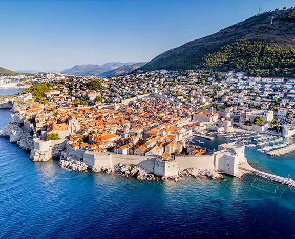
Mljet → Dubrovnik
The leg from Polače to Dubrovnik is 24 miles southeast and on a settled summer day the prevailing W Maestral fills in by mid-morning to push you down the coast. The destination on paper is Dubrovnik, but operationally it is the marina eight kilometres inland — every charter yacht overnights at ACI Marina Dubrovnik in Komolac, set up the long fjord-like Rijeka Dubrovačka estuary. The marina has lazy lines, water and power on every berth, a fuel pontoon, restaurants and a chandler — the lot. The Old Port on the seafront is the picturesque UNESCO walled surface, but it accepts daytime visitors only, is exposed to S gradient, and is saturated with tour-boat tenders the entire season. From the marina pontoon, Bus 1A or a taxi takes you to the Pile Gate of the Old City in about fifteen minutes. The walk is mandatory: start at Pile, climb onto the walls, do the full 1.94 km circuit (90 minutes with the photo stops), then drop down into the Stradun for dinner in a back lane off Prijeko.
Things to do
Walk the 1.94 km Old City wall circuit before sunset
Take the cable car up to Mount Srđ for the panoramic dusk
Eat down a Prijeko side lane, off the main Stradun foot traffic
Visit the Rector's Palace and the Franciscan cloister in one afternoon
Stand a drink at Buža bar, drilled into the rocks outside the south wall
Mooring tip
ACI Marina Dubrovnik in Komolac is the only practical overnight — book ahead in season, lazy lines, full services, summer rate around €180–€220/night for a 50 ft mono. The Old Port on the seafront is a daytime tender stop only, never overnight: it is exposed to S gradient and saturated with tour-boat traffic. Allow 30 minutes door-to-door from the marina pontoon to the Pile Gate via Bus 1A or taxi, plus another 20 minutes inside the gate to the wall ticket office.
Dubrovnik → Okuklje (Mljet)
First leg of the return runs twenty miles back northwest, and Okuklje on Mljet's southeast coast is deliberately the opposite of everything you just walked away from in Dubrovnik: no town, no day-tripper traffic, no Park fees (the bay sits outside the National Park boundary), three family konobas and a tight U-shaped harbour that takes maybe twenty boats. The konobas hang their own free mooring buoys for guests who eat ashore — pick up a buoy, dinghy in, choose a konoba, lock the buoy with the table booking. Standby plates are black risotto (crni rižot, cooked with cuttlefish ink and the day's catch) and grilled bream. The bay is shaped like a long crescent, walled by hundred-metre hills on three sides, so the wind drops dead at sunset regardless of the gradient outside — the night runs silent except for the sea moving on the rocks at the entrance. Off the boat the move is to swim once before lunch, then walk the headland loop — the southern view down to the Pelješac Channel and the south coast of Korčula is the reward.
Things to do
Pick up a free konoba mooring buoy and book the dinner table at the same place
Order black risotto (crni rižot) ink-cooked with the day's catch
Walk the southern headland loop for the Korčula channel view
Dive straight off the bow into flat water at first light
Sleep with zero town noise — the quietest stop on the route
Mooring tip
Free konoba mooring buoys at Okuklje — dinner reservation locks the buoy, confirm with the konoba on arrival. Anchoring on the bottom is possible but holding is patchy in seagrass. Bay is fully sheltered from N, E and S; only NW gradient above 18 knots pushes any noticeable swell into the entrance, and even then the inner half of the bay stays comfortable overnight.
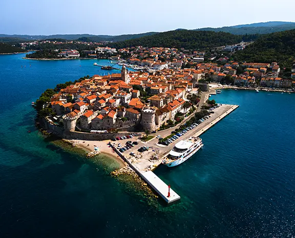
Okuklje → Korčula Town
Fifteen miles northwest along the Pelješac Channel and Korčula Town comes off the starboard bow — the walled medieval port on the eastern tip of Korčula island. The skyline is unmistakable: a small peninsula of red roofs, the single Cathedral bell tower above, the limestone curtain wall sliding into the sea on three sides. ACI Marina Korčula sits on the eastern side of the peninsula with full lazy-line services; the town quay on the western side accepts a few stern-to boats with own anchor at a harbour fee — closer to the gates but exposed to W Maestral and rolly when the channel funnel kicks in around 14:00. The Old Town fits in the palm of your hand — ten minutes walking gets you across it — but the layout is famously the precursor to the radial grids the Venetians later cloned elsewhere on the Adriatic. Headline visits are the Cathedral of St. Mark (climb the bell tower for the channel view), the (disputed) Marco Polo House and the Land Gate with its surviving Venetian relief. Dusk is the right time to walk the streets — after the day-trip ferries have pulled back to Split for the evening.
Things to do
Walk the Old Town at dusk once the day-trip ferries pull for Split
Climb the bell tower of St. Mark's Cathedral for the channel view
Visit the (disputed) Marco Polo House on Depolo Street
Order fish brodet in a back-lane courtyard konoba off the main square
Catch a Moreška sword dance — Monday and Thursday in season
Mooring tip
ACI Marina Korčula on the eastern side of the peninsula is the all-weather option — lazy lines, water, power, full services, summer rate around €150–€180/night for a 50 ft mono. Town quay on the western side accepts stern-to with own anchor (harbour fee, water tap on the central section) but is exposed to W Maestral and rolly after 14:00 in summer. If the channel turns rough, the sheltered alternative is Lumbarda Bay 3 nm southeast — anchorage in sand at 5–8 m.
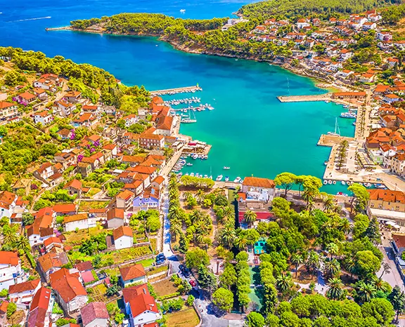
Korčula → Jelsa (Hvar)
Twenty-three miles northwest from Korčula across the Hvar Channel and into Jelsa, the third-largest town on Hvar island, set on the central north coast and roughly half the size and a quarter of the noise of Hvar Town on the south side. The bay opens wide and shelters well from southern gradients; the town quay accepts stern-to with own anchor at a harbour fee (good holding in mud and sand), and a small marina on the eastern side handles boats that need lazy lines and shore power overnight. Jelsa is the working heart of Hvar's interior agriculture: the lavender belt that runs inland to Vrboska and Stari Grad still produces commercial yields each July, and the konobas in the back lanes lean on the local Bogdanjuša white wine and Faros (the Greek-name) cheese. Two strong afternoon options: bike the three miles along the coast road to Vrboska — sometimes called 'the little Venice of Hvar' for its canal-bridged centre — or walk inland through the Stari Grad Plain, UNESCO-listed, one of the oldest continuously cultivated landscapes in Europe (since 384 BC).
Things to do
Bike the 3 nm coast road to Vrboska's canal-bridged old centre
Walk inland through the UNESCO Stari Grad Plain
Pour Bogdanjuša white at a back-lane konoba off the riva
Sample Hvar lavender oil at a roadside producer in season
Climb to the Tor watchtower above the town for the Brač Channel view
Mooring tip
Stern-to on the Jelsa town quay with own anchor — harbour fee around €25–€35 depending on length, water and power on the central section. Bay is well-sheltered from S, SE and SW gradients; exposed to N gradient, which is rare in summer outside the late-season Bora. The small marina on the eastern side has lazy lines and full services and is the all-weather alternative — book online a few days ahead in July–August.
Jelsa → Lučice Bay (Brač)
Ten miles north across the Brač Channel takes you to the south coast of Brač and the chain of small adjoining bays at Lučice, immediately east of Pučišća. There is no town — the headland sits uninhabited, walled by white limestone cliffs and pine forest, and the only structures are the two seasonal beach restaurants that lay free mooring buoys for guests eating ashore. Pick up a buoy in the deepest of the three coves, dive overboard, and the day basically writes itself. The water here is exceptional: the famous white Brač limestone (the same stone the Romans cut for Diocletian's Palace, and reportedly used for parts of the White House in Washington) gives the seabed a pale floor, and visibility runs to 20 metres on a calm summer day. The two restaurants do simple grilled fish and the local Plavac Mali red. There is no nightlife, no shops, and that is the entire reason to stop here. If the buoys are full, anchoring works fine on the bottom in 8–12 metres on a sand-and-weed mix.
Things to do
Pick up a free beach-restaurant buoy in the central cove
Snorkel over the white limestone seabed — 20 m visibility on a calm day
Order grilled fish and a glass of Plavac Mali ashore at lunch
Dinghy 1 nm west into Pučišća to watch the working stone-masons
Stand-up paddle the headland coast at first light before breakfast
Mooring tip
Free restaurant mooring buoys in the three Lučice coves — dinner ashore secures the buoy, confirm with the restaurant on arrival. Anchoring on the bottom is the fallback (8–12 m, sand and weed, holding mostly good with a second pass). Bays shelter from N, NE and E; exposed to S gradient. If S forecast above 15 knots, push 1 nm west into Pučišća harbour, which is fully enclosed and takes stern-to on the working town quay.
Lučice → Krknjaši Bay
The last anchorage of the route is Krknjaši Bay, a fifteen-mile run northwest from Lučice, set in the channel between Veli Drvenik and Mali Drvenik — two small uninhabited islands four miles west of the Trogir charter base. Krknjaši is essentially a swim anchorage: the bay is shallow, the seabed is pale sand at 3–6 metres, the water turns turquoise on a calm day, and the holding is excellent. Three restaurants on Veli Drvenik (no road access — reached only by boat) lay free mooring buoys for dinner guests, but with the shallow sand floor anchoring is the standard choice and free. There is a small chapel on the eastern side of the bay, a footpath that loops the headland in 30 minutes, and no other infrastructure. The reason to stop here on Day 13 is logistical: Saturday return-to-base is four miles east into Marina Kaštela, so the morning runs unrushed and the boat arrives at the base with the right amount of fuel and zero stress. Sunset over the open Adriatic from this position is the quiet farewell to the route.
Things to do
Anchor on the sand floor in 4–6 m and dive straight in for the swim
Walk the 30-minute headland loop on Veli Drvenik
Order grilled fish ashore at a Veli Drvenik beach restaurant
Pour the house Plavac Mali at a quayside table at lunch
Watch the open-Adriatic sunset from the deck before the final leg
Mooring tip
Anchor in 4–6 m on excellent sand holding — the standard choice here, bay is shallow and forgiving. Free restaurant mooring buoys also available with dinner ashore. Bay shelters from N, NE, E, S and SE; exposed only to W and NW. If W gradient is forecast above 18 knots, push 4 nm east directly into Marina Kaštela — the base is reachable on a single tack from this position.
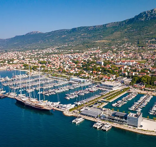
Krknjaši Bay → Kaštela
The last leg is the shortest on the entire fortnight — four miles east from Krknjaši straight into Marina Kaštela, the Croatia Yachting Split-area home base. Saturday handover protocol applies: the boat must be back at base by 09:00 with fuel topped, holding tanks pumped, decks rinsed and inventory checked, and the skipper available for the off-going inspection between 08:00 and 09:00. Marina Kaštela is one of the largest Adriatic marinas by berth count, sitting in the deep west-facing Kaštelanski Zaljev between Split and Trogir, and the run-in is straightforward in any visibility — the marina control tower is unmistakable from offshore. With fuel pumped and inspection signed, the marina is a fifteen-minute drive from Split airport and twenty-five minutes from the city centre. A long walk through Diocletian's Palace and a coffee on the Riva is the standard closing ritual before the airport transfer. Most charter weeks end here on a satisfied silence — the route you have just sailed is one of the longest and most scenic on the Adriatic.
Things to do
Top up fuel and pump out the holding tank before 08:00 inspection
Walk Diocletian's Palace one final time before the airport transfer
Take a closing swim at Bačvice Beach east of the Old Town
Pick up Šoltansko olive oil at the Split Pazar farmers market
Stand a long lunch on the Riva before the transfer leaves
Mooring tip
Return into Marina Kaštela per your charter contract — the base manager directs the slot on radio call ten minutes out. Saturday handover window is 08:00–09:00; if your contract specifies night-before return, arrive by 17:00 Friday. The fuel pontoon is on the western entrance side of the marina; the pump-out station sits next to it. Bring the inventory sheet to the off-going inspection.
Sail this route — we'll match a yacht to it.
Send dates, group size and preferred vessel style. A broker replies with a tailored quote within hours.